
Seen from one direction Winter Hill rises up above the tiny Lancashire (Greater Manchester) town of Horwich in much the same way that the villages of Downham and Barley are dominated by our old friend Pendle Hill. Like Pendle Hill this particular land mass has an extremely steep northern face and a more gentle and approachable southern aspect.The hill is a magnet for walkers from all over the country, its’ 900′ television antenna and various other pieces of ironwork at the summit seemingly not distracting from it’s charm but drawing-in walkers to any one of its’ handful of purpose-built and organic pathways.
This hill has many approaches:

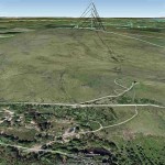
Winter Hill as seen from Two Lads
The Southern approach, is actually a pair of approaches catering for those whom don’t object to a bit of tarmac walking and those people that are happy to stride from one peaty tussock to another. Those of us whom didn’t fancy the idea of the western front of Winter Hill after completing Rivington Pike but still want to ascend the hill are handed a much drier alternative here by heading east from the summit of Rivington Pike, traversing the cobbles akin to Brown Hill (an hill in name only in this author’s opinion), walking along the cobbled and stony Belmont / Rivington Road and turning left at what is now a Dog Hotel at Rivington Pike cottage. SD 64894 13138 From here there is a moderately steep climb that is broken up at the start by a tiny flight of steps with handrail. This route takes one directly over the lesser summit of Two Lads (I hold fast to the belief that Two Lads and Crooked Edge Hill are indeed one and the same landmass and that Two Lads is simply the name for the pair of cairns that used to exist here!). Once within sight of the cairn(s) at the summit of Two Lads cast your eyes a little further to the east and you will undoubtedly see the tarmac of the road to Winter Hill. Even in mid-summer this is a most exposed route with no paving and an abundance of curious sheep. The way forward is easily observed…walk towards the 900′ television mast!

Definately not the yellow brick road! The quagmire that is the western approach to Winter Hill
The South Western approach, from a walkers’ perspective is a perilous, ankle-twisting crawl over marshy and muddy terrain. There are but a few days in each year when a walk across the great western face in an east north east direction is not a soggy experience. Numerous tussocks lie in wait for an opportunity to twist the ankles of even experienced walkers. Steps have been taken including the constructing of a wooden footbridge in an attempt to offer some respite from the ever-present wetness but until some eccentric millionaire decides to dig deeply into his pockets in order to fund the construction of a path strong enough to withstand the trampling of a few thousand pairs of feet each year we shall just have to learn to love the mud or find a better route. This approach is most commonly taken as part of a two-summit walk that includes the lesser summit of Rivington Pike (and its’ notorious steps) but can be extended to take in another lesser summit at Noon Hill to the west. Upon reaching this peak it would be a simple task to drop down the side of the hill to meet with Belmont / Rivington Road and wind one’s way down the lane back towards the approach to the pike whilst taking in stunning views towards Blackpool, the Forest of Bowland and the Southern Lake district.
The South Eastern approach is probably the kindest way to reach the summit of Winter Hill both on the calf muscles and on the feet for this is along a path made-up mostly of the remnants of dry stone walls, old farmsteads and the odd measure of gritstone mixed in with a lot of soil and grass. The path is taken from Coal Pit Road – the crossroads of Scout Road and Smithhills Dean Road spawns this road and it is a good distance along the road before the path appears on the right hand side. The path is famed for being home to the memorial stone that commemorates the mass trespass of 1896 when eight thousand locals defied local land-owner Lord Ainsworth and staked their claim to walk on these moors! The path terminates at the end of the flagged section on the road which is known as Winter Hill; more or less opposite the building that is home to the mighty television mast.

The north face of Winter Hill…not for the faint hearted!
The Northern approach, is probably the most difficult…in Lancashire! After turning West off the A675 (Belmont) road within a mile or so is a lay-by at which five or six cars could be comfortably parked. SD 65522 15788 Either side of the separating road are Hordern Stoops and Hordern Pasture, further north lie the three summits of Spitlers Edge, Redmond’s Edge and Great Hill which are usually combined as part of a great Belmont Moor traverse. The northern face of Winter Hill offers a simply straight-up route alongside a stone wall that must surely have been repaired many times over the centuries which it has stood. Approximately three quarters of the way into the ascent the paths split into two; the deviant left hand of these tackles the rest of the climb at a slightly less acute angle than the right hand one but neither are easy to mere mortals! Once atop the climb turn east then after approximately two hundred metres the ordnance survey column should be on your left hand side. Extensions to this rather exhausting walk could include the drop down into Belmont via Grange Brow and Grange Lodge but be warned this is a steep descent. Turn north onto the A675 for a few hundred metres then take the left hand turn onto Belmont Road once more. Now begins slowly winding but gently increasing climb back to Hordern Stoops. Quite stunning views are to be had in all directions now as Spitlers Edge is shown in it’s best angle, Noon Hill appears to the west of Winter Hill and distant views to White Coppice and the Anglezarke reservoirs come into range.

Winter Hill the north west approach
The North Western approach, is somewhat less severe in steepness but a far more elongated slog up the side of the hill. Using the meeting of the Horderns (as above) as a start off point one must cross the sometime-racetrack Belmont Road once more but this time turn right – head westerly until a track and wide gate appear on the left hand side. Within a further three hundred metres a footbridge is clearly visible on the left hand side (maybe someone would like to inform the Ordnance Survey Cartographers of this!). The continuation of the path is clearly visible all the way to the apex of the north-western face of the hill. The ordnance survey column is found by joining the sandstone and then tarmac path, after several hundred metres the column is on the left hand side.
The North Eastern approach, is the connoisseur’s route up this hill for the scenery is spectacular! Of the two ways of getting onto the path the more scenic is at its’ start back on Belmont Road – the A675, however a shorter and more severe and far wetter route to the path can be taken that indeed does cut out a lot of the leg work and bumps but at the cost of dryness as one tussock after another gives way under each footstep and reveals its’ own micro-reservoir. The route terminates adjacent to the South Eastern “Smithils Moor” route at the crest of the hill just a couple of hundred metres distance away from the ordnance survey column. This route is the one often featured on you tube where an extreme cyclist has recorded themself heading down the hill at a rate of knotts trying to hold on for dear life – this route is not without bumps! The route starts at the A675 either to the north or south of Spring Reservoir to the east of Grange Lodge. A picture will be published when I have one for this is the only approach to Winter Hill that I have yet to attempt.
Winter Hill 456 metres (1,496 ft)
Counting Hill 433 metres (1,421 ft)
Two Lads Hill 389 metres (1,276 ft) / Crooked Edge Hill 375 metres (1,230 ft)
Noon Hill 380 metres (1,247 ft)
Rivington Pike 363 metres (1,191 ft)
Adam Hill 360 metres (1,181 ft)
White Brow 358 metres (1,175 ft)
Whimberry Hill 340 metres (1,115 ft)
Egg Hillock 328 metres (1,076 ft)
Brown Hill 325 metres (1,066 ft)
Brown Lowe Smithills 325 metres (1,066 ft)
Burnt Edge 325 metres (1,066 ft)
Name Locality Elevation OS grid reference
Winter Hill † Rivington 456 metres (1,496 ft)
SD659149
Counting Hill Smithills/Belmont 433 metres (1,421 ft)
SD671141
Two Lads Hill † Horwich 389 metres (1,276 ft)
SD655133
Noon Hill † Rivington 380 metres (1,247 ft)
SD647150
Crooked Edge Hill Horwich 375 metres (1,230 ft)
SD654134
Rivington Pike Rivington 363 metres (1,191 ft)
SD643138
Adam Hill Horwich 360 metres (1,181 ft)
SD660126
White Brow Horwich 358 metres (1,175 ft)
SD661124
Whimberry Hill Belmont 340 metres (1,115 ft)
SD686139
Egg Hillock Belmont 328 metres (1,076 ft)
SD684142
Brown Hill Rivington 325 metres (1,066 ft)
SD644135
Brown Lowe Smithills 325 metres (1,066 ft)
SD669130
Burnt Edge Horwich 325 metres (1,066 ft)
SD667125
† Denotes walker’s cairn or similar.[24]
